
 |
| Happy to be back at Ott car park before midnight |
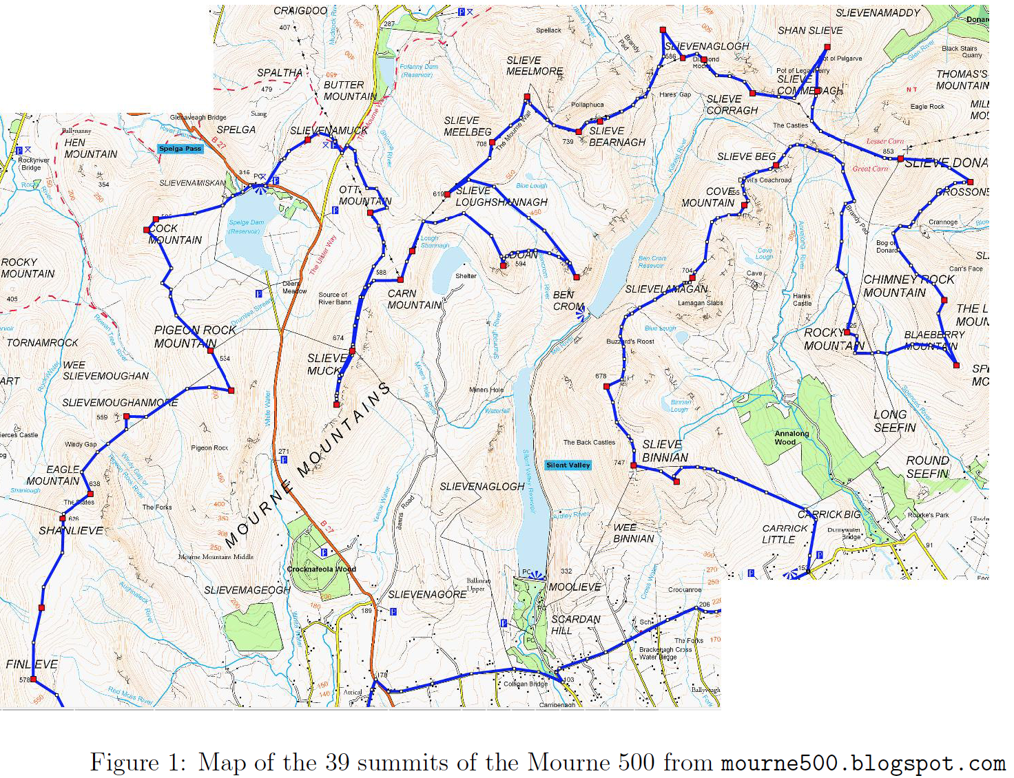
His attempt started at Ott car park at 03:41 and he hauled himself round to finish in triumph at 23:33.
A calf problem on the way up Binnian east took the wind from his sails a bit, but he kept hammering away and still managed to finish with a smile on his face.
Challenge report from the man himself
Mourne 500 Challenge (July 5th, 2016)
Pre Challenge
I first heard about the Mourne 500 challenge in 2013 and was immediately attracted by the simplicity of climbing all of the 39 summits over 500m in the Mournes, unsupported. The seed of making an attempt was sown and I started planning for an attempt. I didn't get time to get up to the Mournes much for a while after that, but after doing the Mourne Skyline race in 2015 the idea was rekindled in my head. After the Skyline race, I dusted off my map of the Mournes and started planning a route for the Mourne 500.

I made four trips up to the Mournes in early 2016 to check out dierent parts of the route. My first trip was a complete washout and I only managed to check out some of the start/finish of the route (Butter Mountain, Carn Mountain and Ott Mountain) and a few river crossings. A clear day in the spring allowed me to cover the first section from Ott car park to Finlieve and I worked out a route to the base of Slieve Muck. My next trip up allowed me to run from Ott car park to Bloody Bridge and to check out a section taking in Slieve Loughshannagh, Doan, Ben Crom, Slieve Binnan (3 summits), Slievelamangan, Cove Mountain and Slieve Beg. One more trip covered a loop including Chimney Rock Mountain, Spences Mountain, Rocky Mountain, Crossone and Slieve Donard. So, between the Skyline race and my recces I was more or less ready for an attempt.
I contacted Rick McKee who co-ordinates the challenge and told him of my plans to attempt it. Because I hoped to use my attempt for UTMB points, I had to complete the summits in a particular order. This wasn't my original planned route, but I was happy enough that my recces would stand to me nonetheless. My plan was to attempt the challenge whenever the weather was right once I had completed the V3k race in June. I kept an eye on the weather forecast for Slieve Donard on www.mountain-forecast.com and it appeared that July 5th was the right day for an attempt. So, on July 4th I drove up to Newcastle through torrential rain, wondering how the forecast could possibly be correctly predicting dry weather the next day.
The Challenge
The alarm was set for 3am on Tuesday morning and after a quick coee, breakfast and last minute gear check, I was dropped at Ott car park by the girls and I started on my challenge at 3:41am. I started up Butter Mountain through swirling mist by the light of my head torch and found that the path up was clearer than I remembered. Quickly, I was on the summit and heading back for the road near Spelga Dam. I hit the road and headed for a footbridge below the dam. On my recce I had gone a good distance below the dam to nd a bridge but on the y I decided to go for a higher bridge crossing which was marked on the map. I followed the river bank under the light of my head torch and eventually found the bridge that I was looking for. The next step was a trudge up Slievenamiskan which is under 500m but was a good reference to navigate my way to Cock Mountain. The cloud level was very low, so I was eyeing my map and compass the whole way to Cock Mountain; I was able to turn o my head torch at this stage. I had a short segment over to Cock Mountain south and then I had to find my way over to Pigeon Mountain North.


The next section involved a boggy descent and climb and I knew that the summit was easy to find because of the Mourne wall. The path seemed very well trodden in places which helped with finding my way in the mist. From Pigeon Mountain North, I had to follow a careful compass bearing to Pigeon Mountain South and then another boggy descent to the col below Slievemoughanmore. I was going to be following the Mourne wall for a while now, apart from a detour to the summit before a very steep descent to the Windy Gap. After a brief encounter with a bog hole, I was heading up Eagle Mountain and continuing along the wall to Shanlieve. The section from Shanlieve onwards is a wide open boggy ridge and in the dense mist was a navigation challenge. I seemed to find a pretty well worn path that was heading in the right direction and it brought me most of the way to the next unnamed summit. I carefully checked my location a number of times until I was confident I had found what the challenge website calls "Highest point on plain" and then I navigated my way to Finlieve. Ten summits done and now I had a long distance to cover before to number eleven.
I took a bearing for the Red Moss river and followed this down out of the cloud and mist towards a road called the Sandy Brae. I spotted a minor short cut across the mountainside which took a few hundred metres o my planned route. I knew that my lack of local knowledge might cost me a bit here, but I opted for following road through the village of Attical for the next few kilometres when making my way to the Silent Valley. My choice of grippy trail runners meant that running on the road wasn’t very comfortable, so I opted for a mix of power walking and jogging for this section. I had a number of people offer me a lift and they were surprised that I wasn't taking up the offer. On entering the Silent Valley, I was looking for a trail that lead towards Wee Binnian and Slieve Binnian. I found a trail, took a minor detour and eventually found my way following a wall towards Wee Binnian. The cloud level was rising and I could almost see the summit of Slieve Binnian and I could see that my originally planned route wasn't going to work, so I picked my way towards Slieve Binnian East. Half way up the climb my right calf muscle developed a pain as if it was strained. I cursed my luck and for a moment thought my day was over already. For some reason, I decided that I'd continue up Slieve Binnian East and although my calf was very sore it was still working and I was able to adjust my climbing to minimize any pain. My plan was to get to the summit and take stock of it there. This was the longest climb of the day but I eventually reached the rocky summit and turned to make the next climb up Slieve Binnian itself. This climb went well and I knew I had easy ground to cover to get to Slieve Binnan North. I found that my calf was working okay on the at and downhill sections but was sore on climbs. The descent was challenging but interesting and I was on familiar ground for the next few hours. I knew that the ascent of Slievelamangan would be a make or break section for my calf muscle.


It was cloudy for this climb, so the climb felt easier that it did on my recce. I was delighted to make it to the summit and knew that the next two summits would come relatively easily. Pretty soon I had climbed Cove Mountain and took a solid break for food and refilling my water bottles before going up Slieve Beg and descending to the Brandy Pad trail. It was easy going along the Brandy Pad trail and I took straight line to Rocky mountain once it was within sight. It was a bumpy way to go but I progress was quite good. A quick stop on the top of Rocky mountain and I descended to the wall and for a path that lead half way up Spences Mountain. This was the hottest part of the day and I filled my water bottles in a mountain stream. I ploughed my way up through heavy vegetation towards Spences Mountain and hit the ridge a bit further North than planned. So, I headed back to Spences Mountain and backtracked towards the summit of Chimney Rock Mountain. The trail along Chimney Rock was very enjoyable and I took a shortcut over to the Brandy Pad before making my way up Crossone. I was happy with my progress and my calf was not getting any worse, so my spirits were lifting but I had a steep climb up Slieve Donard ahead of me.
The climb from Crossone to Slieve Donard felt relentlessly steep. I was grateful that it wasn't very sunny at the time. I enjoyed the varied nature of it, switching from grassy to rocky and back and forth. I particularly enjoyed the grippy rock sections. Reaching the summit was a change because after being on my own all day, I was suddenly on a crowded mountainside. I stopped for a good feed and some time off my feet before descending to the col below the climb to Slieve Commedagh. My descent was at a snail’s pace compared to a bunch of teenage boys who raced down. I picked my way along the Mourne wall to near the summit of Slieve Commedagh and then headed for the summit cairn. From there I followed the ridge to Shan Slieve and it took a while to be sure that I had hit the exact summit.


My original plan was to go back up Slieve Commedagh to rejoin the wall but I changed my mind and decided to contour around to the wall and avoid the climb. The contour was on ridiculously steep ground and I eventually made my way around, after an encounter with a very angry sheep at one point. The summits of Slieve Corragh and the three summits of Slievenaglogh came easily before a descent to the Hare's Gap and the steep climb up Slieve Bearnagh. I knew that this was the toughest climb that I had left and I slowly picked my way up towards the summit. I got as close to the summit tor as I could and made my way up to the second and higher summit tor before the steepest descent of the day on my way towards Slieve Meelmore. Before the descent, I took a brief pause to enjoy some of the best views of the day off Bearnagh.


I was starting to feel like I was on the home straight and slowly picked off Slieve Meelmore, Slieve Meelbeg, and Slieve Loughshannagh. My route choice had me backtrack off Slieve Loughshannagh to head for Ben Crom in the distance. This route took me along an easy trail for a while and then I had a relentless bog trot to the base of the final climb. The sun was getting low in the sky and I pushed my pace as hard as my calf would endure to make sure that I got back to the Mourne Wall before it got dark. The summit cliffs of Ben Crom were impressive and the mountain literally falls into the Silent Valley. I'm not sure if I found an optimal route to Doan, but I crossed the bog and found a new water supply and soon I was on the trail to Doan's summit. Just near the top of Doan I suddenly had a small slab of rock to cross, it had me thinking \easy to get up, not so easy to get down" but I got up it. I went over on my ankle on the summit, no damage done, and I slowly slithered my way back down the slab and headed along a good path to the col between Slieve Loughshannagh and Carn Mountain. I was chasing day light at this stage and managed to lose the path. I also realized that my assessment of which mountain was which was wrong too. I was actually heading for the col to the East of Slieve Loughshannagh whereas I should be going for the west col, this error would have meant extra climbing so I was glad I spotted my error.
When I reached the col I knew that I had five summits to go. Carn Mountain North and Carn Mountain came quickly and this section was taking me away from the finish. The climb up Slieve Muck was long but not very steep and then I had to descend to Slieve Muck South. I started moving as quickly as my legs would allow because the light was fading seriously quickly. I reached the summit, turned around and pushed hard to get back to the summit of Slieve Muck again. I knew from there I had just over three kilometres to go to the finish. The next kilometre followed the Mourne wall and it was dark enough to need a head torch again. I moved as quickly as I could and had a few near trips and falls, but stayed on my feet. After a kilometre the wall swung right and I took a bearing from my map towards the summit of Ott Mountain. It was completely dark now so I just followed my compass bearing in a blind manner and climbed over any obstacles in my path; I did notice I was veering too far right of the bearing a few times but then stuck to the correct bearing religiously. Eventually I started climbing again and kept on the bearing until all the ground around me was downhill. I had reached the last summit and just needed to get to Ott car park. I could see the lights from the car in the car park so I headed straight in that direction and descended over a few tricky obstacles en route. Eventually, I hit the Ott track and was able to jog to the car park. The girls were there to welcome me to the finish and it was great to see the first people since the Donard col almost eight hours earlier.
Post Challenge
The Mourne 500 is a great challenge and I really enjoyed it. I think doing it alone was tougher than I had anticipated. The longest stretch that I went without seeing anyone was eight hours, but I pretty much only met a handful of people on the whole route, apart from on Donard summit and its descent. I think I got the fuelling correct and might even have carried a little too much food in the end. I could say that my dodgy calf slowed me down a lot, but I think that going slower early on might have left me with more in reserve at the end. I reckon some local knowledge from extra recceing would have helped fine tune my route, but it worked out okay in the end. I'll definitely be back in the Mournes for some more runs soon.